
Profile
|
Zain Selman, M.Sc. |
Publications
Bijective Feature-Aware Contour Matching

Computing maps between data sequences is a fundamental problem with various applications in the fields of geometry and signal processing. As such, a multitude of approaches exist, that make trade-offs between flexibility, performance, and accuracy. Even recent approaches cannot be applied to periodic data, such as contours, without significant compromises due to their map representation or method of optimization. We propose a universal method to optimize maps between periodic and non periodic univariate sequences. By continuously optimizing a piecewise linear approximation of the smooth map on a common intermediate domain, we decouple the map and input resolution. Our optimization offers bijectivity guarantees and flexibility with regards to applications and data modality. To robustly converge towards a high quality solution we initially apply a low-pass filter to the input. This creates a scale space that suppresses local features in the early phase of the optimization (global phase) and gradually adds them back later (local phase). We demonstrate the versatility of our method on various scenarios with different types of sequences, including multi-contour morphing, signature prototypes, symmetry detection, and 3D motion-capture-data alignment.
Awards:
@inproceedings{10.2312:vmv.20251243,
booktitle = {Vision, Modeling, and Visualization},
editor = {Egger, Bernhard and Günther, Tobias},
title = {{Bijective Feature-Aware Contour Matching}},
author = {Selman, Zain and Speetzen, Nils and Kobbelt, Leif},
year = {2025},
publisher = {The Eurographics Association},
ISBN = {978-3-03868-294-3},
DOI = {10.2312/vmv.20251243}
}
Scan2FEM: From Point Clouds to Structured 3D Models Suitable for Simulation
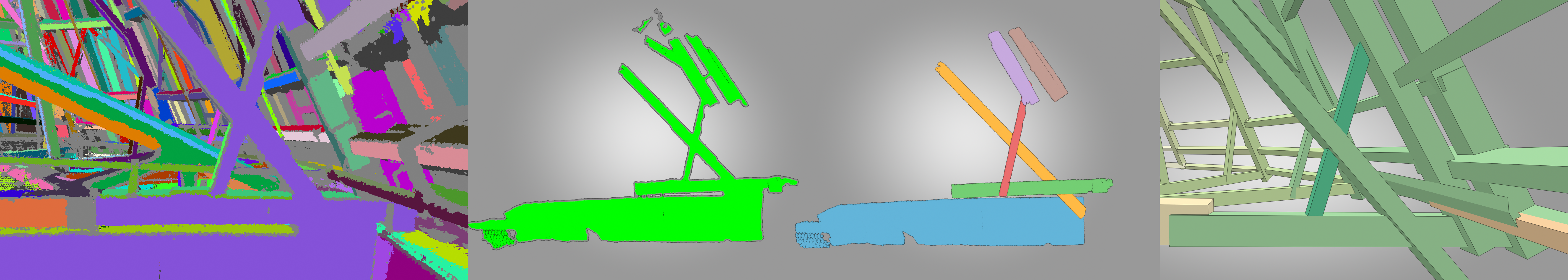
Preservation of cultural heritage is important to prevent singular objects or sites of cultural importance to decay. One aspect of preservation is the creation of a digital twin. In case of a catastrophic event, this twin can be used to support repairs or reconstruction, in order to stay faithful to the original object or site. Certain activities in prolongation of such an objects lifetime may involve adding or replacing structural support elements to prevent a collapse. We propose an automatic method that is capable of transforming a point cloud into a geometric representation that is suitable for structural analysis. We robustly find cuboids and their connections in a point cloud to approximate the wooden beam structure contained inside. We export the necessary information to perform structural analysis, on the example of the timber attic of the UNESCO World Heritage Aachen Cathedral. We provide evaluation of the resulting cuboids’ quality and show how a user can interactively refine the cuboids in order to improve the approximated model, and consequently the simulation results.
@inproceedings {10.2312:gch.20221215,
booktitle = {Eurographics Workshop on Graphics and Cultural Heritage},
editor = {Ponchio, Federico and Pintus, Ruggero},
title = {{Scan2FEM: From Point Clouds to Structured 3D Models Suitable for Simulation}},
author = {Selman, Zain and Musto, Juan and Kobbelt, Leif},
year = {2022},
publisher = {The Eurographics Association},
ISSN = {2312-6124},
ISBN = {978-3-03868-178-6},
DOI = {10.2312/gch.20221215}
}
Automatic region-growing system for the segmentation of large point clouds
This article describes a complete unsupervised system for the segmentation of massive 3D point clouds. Our system bridges the missing components that permit to go from 99% automation to 100% automation for the construction industry. It scales up to billions of 3D points and targets a generic low-level grouping of planar regions usable by a wide range of applications. Furthermore, we introduce a hierarchical multi-level segment definition to cope with potential variations in high-level object definitions. The approach first leverages planar predominance in scenes through a normal-based region growing. Then, for usability and simplicity, we designed an automatic heuristic to determine without user supervision three RANSAC-inspired parameters. These are the distance threshold for the region growing, the threshold for the minimum number of points needed to form a valid planar region, and the decision criterion for adding points to a region. Our experiments are conducted on 3D scans of complex buildings to test the robustness of the “one-click” method in varying scenarios. Labelled and instantiated point clouds from different sensors and platforms (depth sensor, terrestrial laser scanner, hand-held laser scanner, mobile mapping system), in different environments (indoor, outdoor, buildings) and with different objects of interests (AEC-related, BIM-related, navigation-related) are provided as a new extensive test-bench. The current implementation processes ten million points per minutes on a single thread CPU configuration. Moreover, the resulting segments are tested for the high-level task of semantic segmentation over 14 classes, to achieve an F1-score of 90+ averaged over all datasets while reducing the training phase to a fraction of state of the art point-based deep learning methods. We provide this baseline along with six new open-access datasets with 300+ million hand-labelled and instantiated 3D points at: https://www.graphics.rwth-aachen.de/project/ 45/.
@article{POUX2022104250,
title = {Automatic region-growing system for the segmentation of large point clouds},
journal = {Automation in Construction},
volume = {138},
pages = {104250},
year = {2022},
issn = {0926-5805},
doi = {https://doi.org/10.1016/j.autcon.2022.104250},
url = {https://www.sciencedirect.com/science/article/pii/S0926580522001236},
author = {F. Poux and C. Mattes and Z. Selman and L. Kobbelt},
keywords = {3D point cloud, Segmentation, Region-growing, RANSAC, Unsupervised clustering}
}
